My knee is continuing to heal well. As soon as all the scabs drop their own I can back in the pool which will be great!!
I’ve transitioned from Home Health PT to Outpatient PT. So I am going to a place twice a week where I pay people to torture me. They give me homework to do so my therapy cat Lizzie checks it to make sure we are doing everything right. She’s a funny cat. Whenever I got on the bed to do something, she’s right up there with me. If you don’t have a therapy cat I suggest getting one.
I’ve started taking Heather’s cardio drumming classes again. I started out seated and now I can stand for half the class before I have to use the chair.
Last week I went on my first walk all by my lonesome. First I had to check out a fire we had in the greenbelt behind our house. Apparently a squirrel shorted out a transmission line, caught on fire and dropped into some brush which caught on fire. The fire department on was on it quickly fortunately.
I went on walking and heard this loud bird. I could see him but couldn’t figure out what it was so I fired up the iMerlin app on my phone.
Brown Thrasher it said. A new addition to my life list!
Found a big field of henbit. Years past I would attack in our yard but I’ve come to find out that it is an important source of food in the spring for pollinators. So now I let it be.
My little outing was a little less than a mile and left me exhausted, sore, and very happy. Time to get back to the house and put some ice on the leg. So yep, things are looking up.
The first day of the year is a big deal for hikers and geocachers. I went to a private park to find a first day geocache. And I got a “souvenir.”
I went looking for another geocache close by. The area it is in is a mess.
Lots of spray can graffiti. I hate it the colorful mess.
It is quite popular. I found the cache but I cannot count it.
It was way up in a tree. Do you see the black tube at the top of the photo. In year’s past I would go ahead and climb the tree. I could probably do it now but I am 69 years old and the penalty for falling could be bad. (Maybe I couldn’t climb the tree. My orthopedic doc says I need a complete new right knee. Soon, I am going to enlist my wife to come with me to go visit him and get it scheduled.) So I can’t count it as a find because to do that you have to open the container and sign the log. I’m kind of a stickler for that.
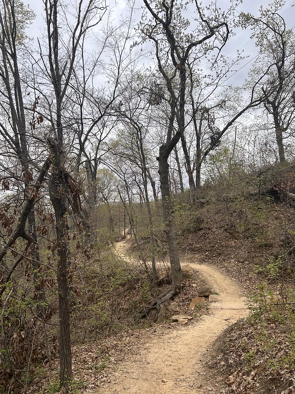
I went on a first day hike as well. I went on a one mile loop at Turkey Mountain. The trail was named by the Muskogee Creek Tribe. I am not sure what it means.
Winter is a time for either no shadows during long periods of heavily overcast days or long shadows. I love the long shadows of winter.
I went for a walk near the new Zink Dam and Williams Crossing Bridge on the Arkansas River. There was a long bridge shadow on the water. Don’t remember too many water shadows.
The playgrounds that are busy when it is warmer are empty in the winter. This looks like a fun place to play. The ground surface is ultra spongey to keep little ones from getting hurt.
I walked over the Gathering Place and checked the shadows out there as well.
I am wishing everyone a Happy and Healthy New Year 2025!!
I hope that everyone had a great New Year’s. 2024 was a year of blessings and also trials and tribulation for us and we got through it. Back when I started blogging, there was a friend of mine who also started and quit because she said people only put the positive parts of their life online so it was dishonest. So I guess I am dishonest. Sorry about that and I don’t feel bad about it all. I’m a blessed man, what can I say. I have this irritating trait that no matter what the situation, I think things will be okay. I couple that with a sense of realism about what okay looks like.
I have always loved New Year’s. It’s like a fresh start every year. We didn’t do much, stayed home, had a nice dinner, watched some television.
In late December after weeks of monotonous gray skies I saw that things were shaping up for maybe a good sunset so I got my drone in the air and captured a bunch of images. I put them in a video and here it is. It is only twenty seconds long so do not panic!
New Year’s Day morning I went with Heather to a class she is starting at a nearby YMCA. It is cardio drumming and twenty people showed up to take it. Not bad for a brand new class. She is already teaching it weekly at another YMCA here in town and monthly at our “home gym.” It is lots of fun, you have drumsticks and you drum on an exercise ball in time to music. She leads the different moves. It is lots of fun, she loves upbeat music and so do her students. She also teaches Zumba at two different gyms, and a couple water classes, aquazumba and aquastrength. I take both of those classes. She stays pretty busy. She has been teaching for years and is very good at “reading the room” providing alternative moves for those who need them.
Afterwards, I took off and found a geocache and hiked a short distance. If you are a geocacher, New Year’s Day is an important day to find one and if you are a hiker you should go on a First Day’s Hike. So I did both. Yeah me, hah!
And then we went home and had our New Year’s Day meal featuring chicken quarters and baby back ribs that I smoked on the day before New Year’s Eve. That red stuff on the meat is a very spicy rub use. It brings the heat.
Meanwhile, I did another jigsaw puzzle on my ipad. Great way to stay busy while we watch our streaming shows. The one I am working on now is a Canyonlands scene with lots of tan colored desert and skies. Very challenging.
Again, I wish everyone a Happy, Heathy, and Prosperous 2025!
One day late in October it was very windy. Windy days I like to go to Oxley Nature Center, especially their Sierra Club Trail. You can hear the wind howling in the treetops but it is calm down on the ground.
And I hardly ever see anybody. This trip I encountered only one person. A guy headed towards me looking kind of angry and upset. I had my spidey senses going but he passed me without looking up. I could hear him walking past in the leaves, crunch, crunch, crunch. Any change in the pattern and I would have looked around. But nothing happened. I’m not going to begrudge anybody needing a little solace in the woods.
I took a small garbage bag and my grabbers with me. The places I go hike there is hardly ever any trash. This day I found just a few cans and wrappers and that was it. Put the trash in the trashcan at the trailhead at the end of my hike.
It was a feast of Oklahoma style fall color. We don’t have a whole lot of color in the fall besides some yellows and browns. I’m okay with it.
Here’s a little reddish color for you. My Merlin ID app was going crazy with all the birds in the area. I was going crazy with inability to see such birds, except as small specs when they took off. I saw lots of squirrels and a glimpse of a deer. Kind of a zero day for photographing animals.
And a short video of the wind in the treetops.
And at the end, I see where a city surveyor had set up shot. I hope that they are not putting a new freeway in!!
A little shy of 3 miles, a nice walk in the woods is what I thought.
I went hiking the other day and took a couple of shadow selfies. Here’s a fuzzy one. Do you see little old me? I think it is fuzzy because the image focused on the bridge I was standing on. That is coming in clear.
And here is a big selfie. I love how afternoon shadows make me look slimmer. And wrinkles don’t show up on shadow selfies either.
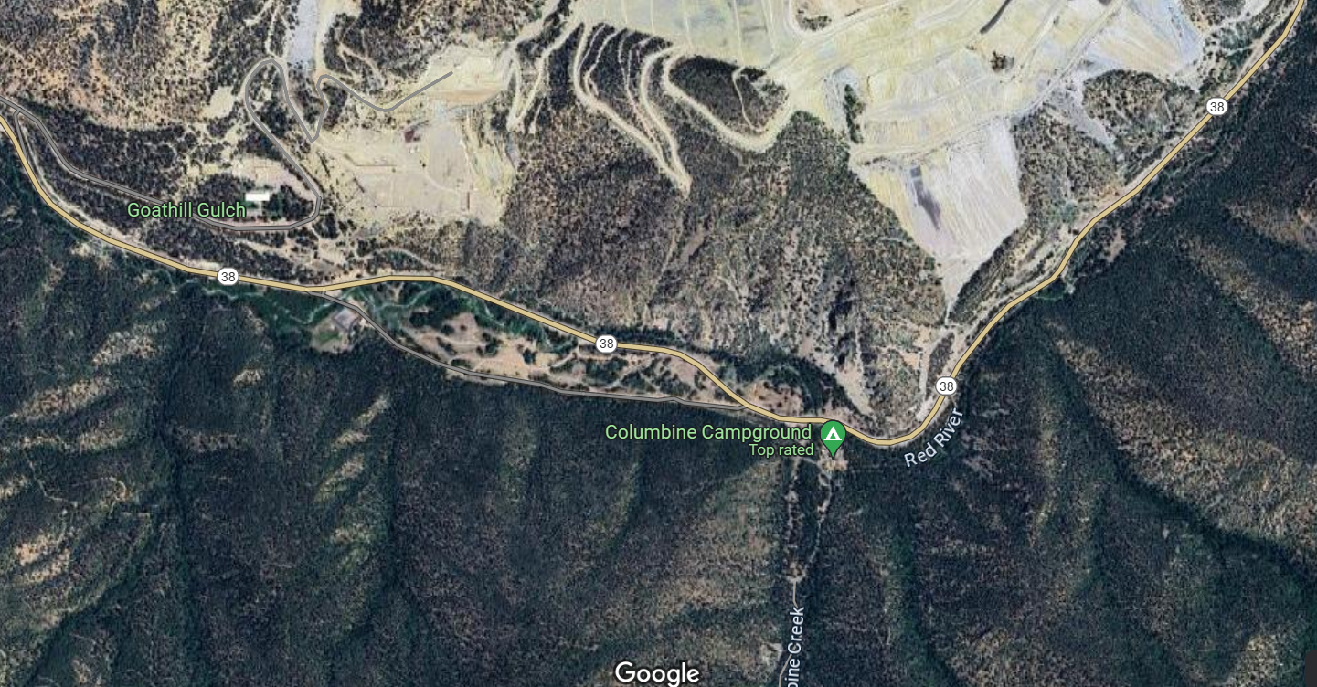
Continuing our saga of our New Mexico vacation. We got to Red River in the beautiful Sangre de Cristo Mountains and didn’t waste any time hiking the day after we got there. I hadn’t been in the area in 50 years and back then I wasn’t a hiker. So we consulted the redriver.org website and the alltrails app and kind of converged on the nearby Columbine Creek Trail as a good moderate trail. Plus it was only about five miles from town so off we went.
We didn’t see much in the way of critters but there were wildflowers. I had my Merlin App going and it captured the Northern Flicker in a particular section of the trail and not much anywhere else. I caught glimpses of it but not enough to feel comfortable adding it to my “life list.” Those dang birds need to sit still for at least 30 seconds for me to get my camera out, adjust the settings, focus and all that to get a good photo. Those little birds are so rude they way they hop skip and jump all over the place. Just call me Karen and point me to the manager.
Gotta tell you walking through an aspen forest got my feels going. Did that all the time when I was just a kid. Haven’t hardly done it since. I love it. Brings back lots of memories.
And a cold, clear mountain stream. We have lots of water in eastern Oklahoma (and I love it here) but very few clear running streams.
Just one more time on the aspens. Promise!!
The trail crossed Columbine Creek several times. The Forest Service put in these deluxe bridges. I cannot imagine the amount of work to put the bridges in and then keep them maintained.
And I loved the rock cliffs.
I googled the heck of “Quetta” so I don’t know who this person is but they obviously loved the trails.
Here’s two of my hiking team.
We didn’t make it to the promised waterfall at the end of the trail. We were getting low on water and we are flatlanders playing around at over 10,000 feet so we turned around. There will be plenty of waterfalls in our future. So headed back to the trailhead and got there safe and sound. So we got four miles in for the day.
And now a blast from the past.
Our hike reminded me that when I was in high school our family hiked somewhere along the highway in one of the Forest Service campgrounds. I remember dad pointing up to a mountain and saying that there was lots of molybdenum in the rock and that it had been mined there for decades. The mineral is used to harden steel in everything from bulldozer blades to mountain bikes and is very valuable. So I looked it up and molybdenum had indeed been mined there for a long time and the biggest mine, owned by Chevron Mining, was an open pit mine right across the road from the campground where our trailhead was. I got on google maps and the mine looks a lot worse than it looks from the road. It is a huge open pit mine.
Chevron shut the mine down in 2014 and settled with the State and the Feds for over $140 million in cleanup costs from the damage of runoff from the mine into the Red River. Chevron is still cleaning it up and is still helping the downstream village of Questa deal with transitioning their economy from mining to something else. Mining is necessary for our modern life but cleaning it up is an expensive, lengthy process. I think they are pretty close to completing the project.
Hey I apologize for digressing but I found the mine fascinating and was amazed at how much damage it caused to the surrounding area.
One day last week I started out from Turkey Mountain’s upper parking lot and had to check this device. I’d love to have one in case anybody is wondering what to get me for back to school! I’m not going to school but you can buy it for me anyways.
And then I went tot the north end of the parking lot and took this shot of downtown Tulsa. Turkey Mountain is a true urban wilderness. It’s only about six miles to downtown.
And then I took the new Three Pillars Trail over to the Three Ponds. I keep hearing they are the three sisters or the three pearls. So I don’t know about those names but they are definitely ponds so I am using that for now.
They are going to make some great season photographs.
Nice reflections everywhere you look.
I left the ponds and continued westward when I found this fella. I posted this same photo on my Saturday’s Critters post last Saturday. It’ a rat snake, and they are not venomous.
And then went and checked on my most previous employer’s pipeline they are building through the park.
They are doing a good job. The right of way is in good shape and the welders, pipefitters, equipment operators, x-ray hands, and inspectors are not out and about wandering all over the place, poaching deer and fishing the ponds. At least not during working hours.
I’m told that they are going to be done pretty soon and they are going to mulch the right of way and plant a wildflower mix. That sounds good to me.
I went a little bit further and find a couch to relax on. It looked a little firm to me so I just kept moving.
Went down a side trail and had to double back. The pipeline folks were excavating and didn’t want any tourists or know it all retired pipeline engineers.
I passed this little mess. Years ago, Turkey Mountain was an oilfield and the workers had trash pits they covered up. Well they are getting exposed now and the old trash is coming to the surface.
And then I went back to my car. I was hot and tired. It is warm here in Tulsa.
The other day I grabbed up my hiking gear and headed out to Tulsa’s Turkey Mountain Urban Wilderness. I took my “grabbers” and a small grocery bag to gather trash. People are pretty good about picking up after themselves so I used to take a small garbage bag but I usually only find an item or two during my hikes.
I took a little side trail pretty soon after the trailhead to find a geocache.
And yep I found it. Another use of grabbers is to grab into places you can’t see so that mr snake doesn’t clamp down on my hand. That would ruin my whole day.
I didn’t see too many critters. A few squirrels maybe, no big critters. I took along my Merlin Bird ID app on the phone. It’s amazing. Turn it on audio mode and it identified: Red-eyed vireo Tufted Titmouse Carolina Wren Northern Cardinal I didn’t see a one of them!! I glimpsed small birds flitting around in the thick woods but I couldn’t vouch for any of them. One I did get a good look at looked like a small woodpecker with a redhead but it wasn’t making any sounds. I don’t know what it is though. It’s kind of frustrating but kind of fun as well. I think being able to spot and ID them will come with practice and patience.
I came upon a fallen tree on one of the small legacy trails. I took a photo of it with my Solocator app which puts the coordinates on the photos and posted it on Turkey Mountain’s facebook page and they had it cleared before I ended my hike. You gotta have the apps folks.
I got to Pepsi Lake and looked around.
I found a mess that somebody left, including a styrofoam cup and some fishing spinner bait packaging. Why can people not haul out what they haul in?
And a Pepsi can, at Pepsi Lake! All the trash fit into my shopping bag that I brought.
I kept heading north and heard some construction type noise. Excited that more trails might be under construction made me hurry to find the source.
It was pipeline construction going on. Ironically my former employer is having to relocate a line because of some highway construction and they cut a deal with my employer before that to lay in their right of way.
That’s not the way the energy industry typically was back in the old days. You had to have sharp elbows to survive. We didn’t spend too much time holding hands and singing Kumbaya with competitors let alone helping each other out. So maybe it is a kinder and gentler industry now?
So I followed the construction from a distance just to make sure that they are doing it right. I guess they are and I was getting tired so I headed back to the parking lot.
Went on a hike on Turkey Mountain this week. (Like almost all weeks)
Checked out the new trail construction going on at the “String of Pearls.” Three ponds that used to be inaccessible because of thick shrubs and thorns.
Checked out the panoramic view at “The Hub” – the highest point on Turkey Mountain and has several trails going in and several going out including two wicked bicycle downhill runs.
We had a decent sunrise the house the other day.
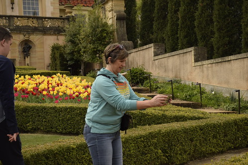
I went to Philbrook Museum’s gardens and checked out the tulips.
And a perfectly formed maple tree.
Made a photo of tulips, a redbud tree, the Tempietto, and the sky.
I told my wife Heather all about it.
So I came back with her the very next day.
The tulips and everything else and more was still there.
Son Logan came with us and we checked out the Cabin.
And had some ice cream at a nearby place. A good time was had by all.
And yet another Lego critter, this time a zebra from our earlier trip to the Tulsa Botanic Garden.
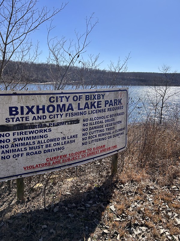
Lake Bixhoma is a water supply lake for the Tulsa suburb of Bixby. It is known for its clean water and protection from wind since it is surrounded on three sides by hills. It has a few hiking trails that are known for being kind of tough plus they have all sorts of venomous snakes there. I’ve been lucky and never seen one except for a water snake last year. The place also has a geocache that has not been found in four years. So I wanted to do two things. Find the cache and hike completely around the lake which I have never done before. I also wanted to lessen the chances of serpent encounter by doing the hike while the snakes were still in brumation (the snake form of hibernation.)
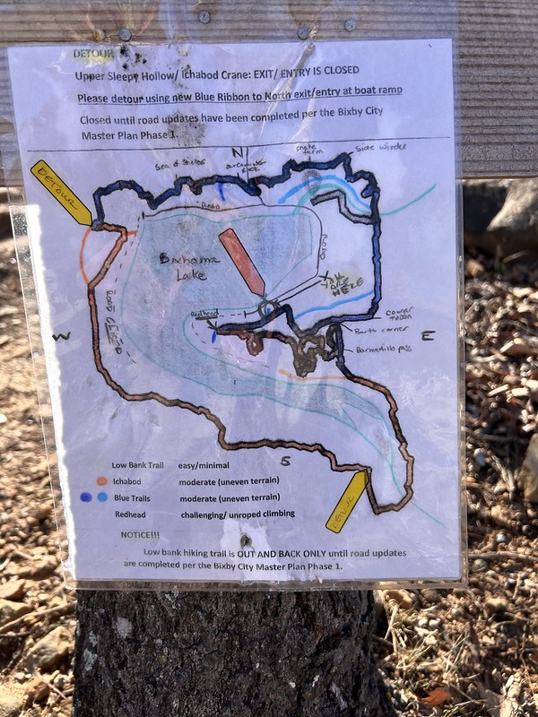
So I started off at the beginning. I couldn’t make heads nor tails of this map at the time. All I wanted to do was avoid the “snake farm” indicated on the upper part of the map. Off I went. You don’t really need a map. Just keep the lake in sight and you’ll be okay. That turned out not to be totally true.
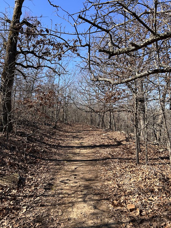
The trail is a mix of old road, nice single track and some pretty technical rocky sections.
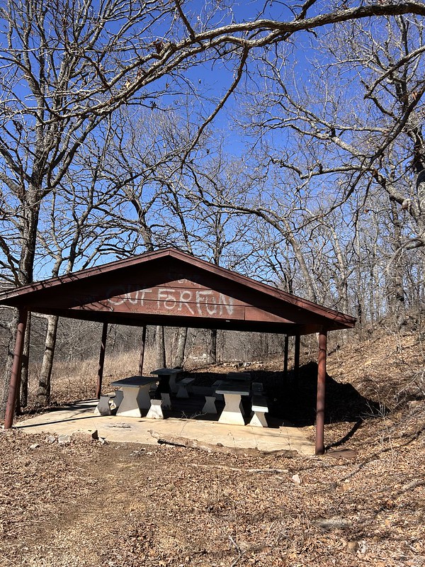
They used to have a road that went deeper into the park and had picnic pavilions, restrooms and such. These are now abandoned.
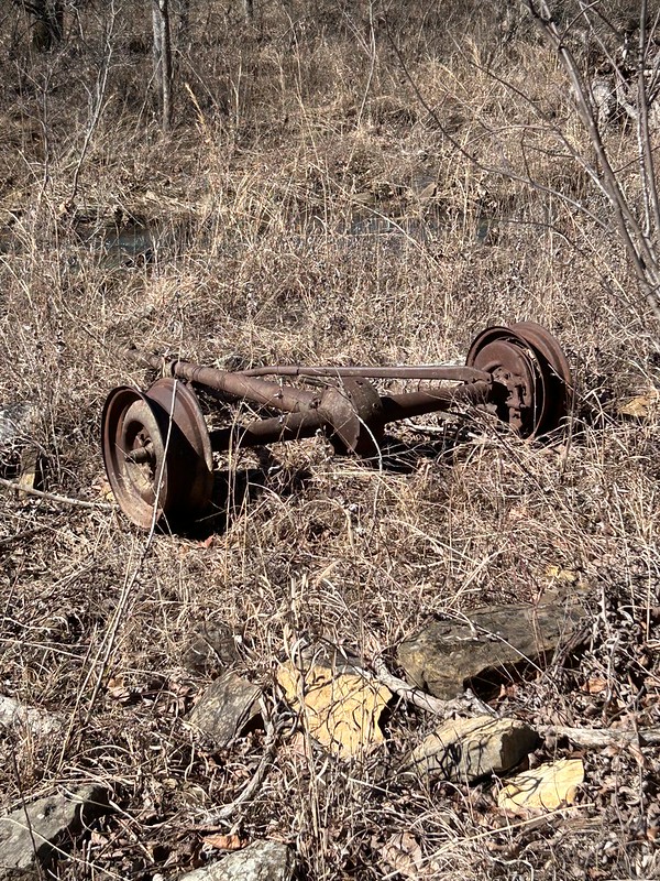
There is evidence of old farms and houses here. I’m told that this is a model T axle. How it got there, I don’t know.
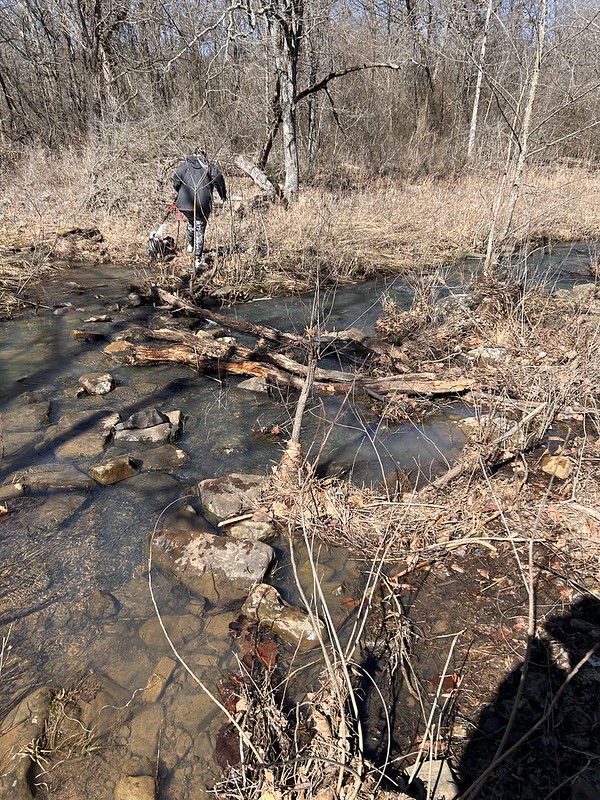
There is a little creek flowing into the lake.
Last year I came looking for the cache and turned back at this creek crossing. I had my good camera with me and no walking stick. So I didn’t want to take a tumble into the water. This year I came upon a young woman who had two dogs on leash who was considering the crossing and went ahead and did it even though the dogs were pulling here pretty hard. I said, okay if she can do it I can so I got across with dry feet.
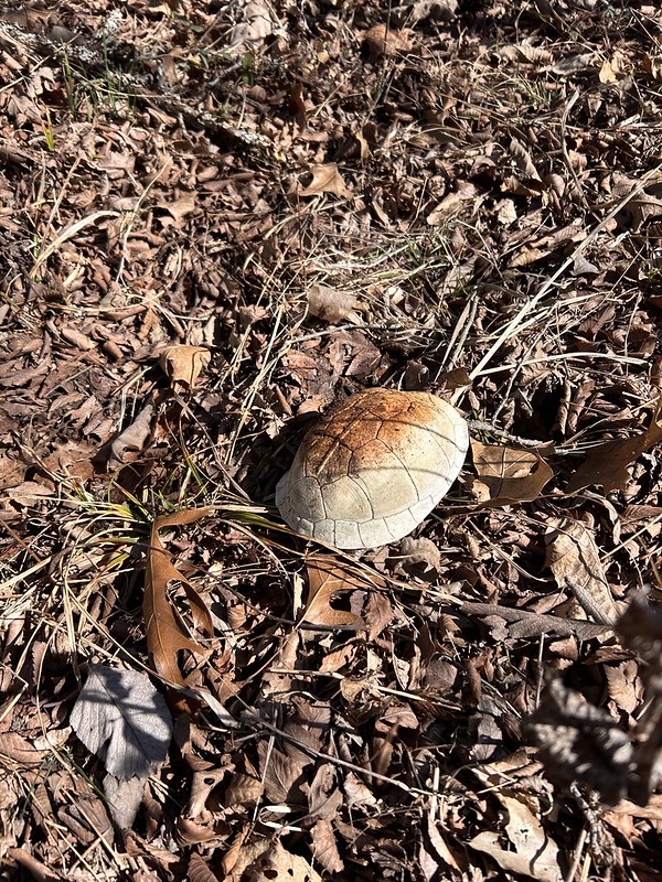
Soon after crossing I started deadheading to the cache. No trail so I was going around thorns and such. Found me this old turtle shell.
And a skull of some unlucky critter.
I got to ground zero which was almost on the lake. It looks like one could take a kayak almost all the way there. In fact almost all the previous finders used a kayak but had to beach it in marshy areas and get all muddy coming in.
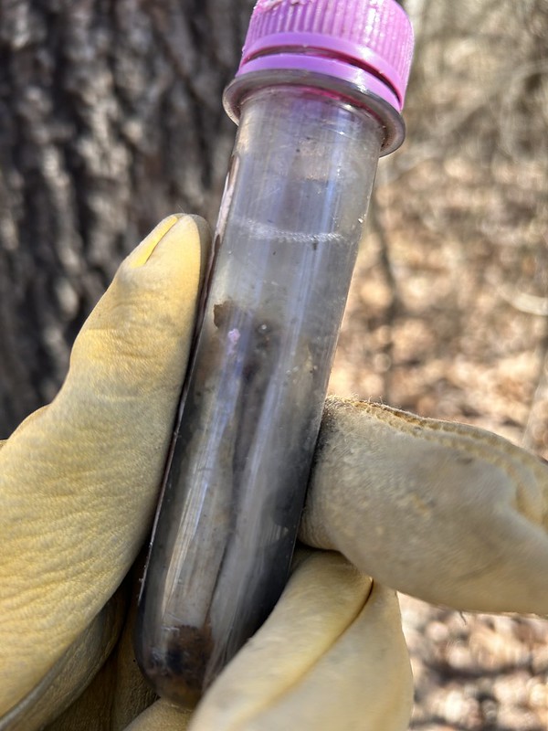
I looked for the cache for an hour. I was envisioning something big like an ammo box. I was convinced that the cache had gone missing. “Muggled” they say in the geocaching world. I looked for it for an hour or so and couldn’t find it. I had marked ground zero with my blue water bottle and when I gave up looking for the cache well then I couldn’t find my bottle. So I had to hunt for the water bottle and when I found it, I saw the cache. Which is why I marked the zero point with my bottle. I could have saved an hour, oh well.
The thing is that the cache container’s top had been chewed by some critter and the container was level full of water. So I obviously could not sign the log. I’m still claiming it! I logged the find online and cache owner got back with me and said that they would replace the container.
So then I hiked out. Since I wanted to circumnavigate the lake I had to take the long way out. It was a mile and a half to the cache site and I hike almost two and a half miles to get back out. A good time was had by all is my motto.