Back in May the weather turned warm, the sun came out, and off Heather and I went to the nursery. We went to a gigantic place way out in the boonies.
There’s my bride Heather going full speed in the nursery. She is a certified Oklahoma State University Master Gardener and she is reinvigorated this spring to get some plants. I went along to pull the cart and take photos. I don’t necessarily take photos of what she is buying.
Pink Impatiens
Colea
French Marigolds
More French Marigolds
Plum Cockatoo Petunias
Even more French Marigolds
Dayglo Yellow Dahlia
Black Mamba Petunias – my favorite plant name for the day
Orange Marigolds
Callie Pink with Eye Syngenta Flowers
And a large Garden Ornament on the way out.
A good time was had by all. Heather got lots of plants, I got lots of photos.
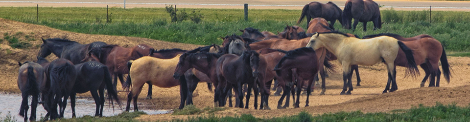
As part of our trip to southeast Oklahoma’s Hochatown we visited the Beavers Bend Safari Park. They have quite a collection of animals. Many in enclosures and others out in the woods confined by fences but otherwise roaming around. I’ll post about the roaming animals next week.
Common Emu
A vervet monkey. Sorry about the camera focusing on the cage instead of the animal.
A couple months ago I stopped in the Tulsa suburb of Sapulpa to check things out.
Close to the downtown of the city I saw this large church. It was very imposing but I thought it looked a little awkward looking with that steeple that seems to need to be attached to a much larger building.
It is Prase Fellowship Church. I don’t know much about it but I liked the design on their sign showing clasped dark and light hands. I guess I am woke but I like the imagery. We need more woke stuff in my opinion.
The core downtown of Sapulpa has all sorts of trendy stores, restaurants, and a brewery. I liked this “umbrella alley” I’ll call it. I know lots of other places have similar installations but this is the first one I have seen. I love the different colors. The thing about Oklahoma is that the wind blows a lot here and the these umbrellas were dancing around pretty good. It looks like there are a few gaps where maybe a few umbrellas just flew off.
This is a mural on the city’s performance playhouse. I love murals and I think this fits.
And this is interesting. At first I thought it was a bar for surveyors or geocachers. Nope, its an outdoor event space.
Route 66 runs right through Sapulpa and there a lot of Route 66 themed stores and restaurants in town. This was on the outskirts. It is a barbecue restaurant. It wasn’t open when I was there.
So after seeing the sights I headed back home to Tulsa. I am linking to Through My Lens.
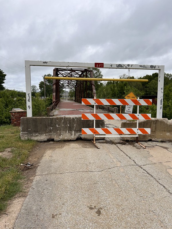
Here in the USA, a big deal this year is that it is the 100th Anniversary or Route 66. The cross country highway between Chicago, Illinois, and Santa Monica, California. Made famous in the book, “The Grapes of Wrath” by John Steinbeck telling of the migration of people from the Midwest to California during the depression. It has since become a destination in itself of people wanting to make the trek. All up and down the length of the road, individuals, cities, and states are sprucing up their attractions along US 66 for this year.
Oklahoma is full of Route 66 attractions and I have been to almost all of them. The Tulsa area has its share, including Rock Creek Bridge near the suburb of Sapulpa. The above photo was taken in 2021 when one could still drive across it.
Below is two years ago when it was blocked off because of safety concerns. You could still walk across it with no problems.
What has happened since then is that plans were made and money was spent and a grand opening was held this past April making this bridge a destination.
They have parking areas, picnic tables, lights.
And walkways so you could legally get an angle to get better photos of the bridge. Before you might have to venture out to some pretty thorny, snaky areas, to get a shot but now you can do it safely. They still have that big ugly power pole to deal with but it’s authentic.
You still can’t drive on it. But that is okay. This is the view from east to west. I think the bricks are mainly original.
And this is from west to east. Yep, I used a filter on the photo because the sky was white and not too pretty.
And a sign and sitting area, just waiting for people to make selfies.
And an old vintage truck is installed.
And an old decorated, still in service, oil tank as a background.
It’s nice to see things spruced up.
Here is a link to an article by the National Park Service on the Bridge, and here is a link by a local television station that covered the grand opening festivities.
I went on a bike ride during a sunny, cool morning this week. It was glorious. I stopped here at the Arkansas River as it goes through Tulsa. That bridge going across the river is Williams Crossing, named for the corporation that donated about one gazillion dollars to build it. I saw some people gliding, almost flying across the bridge.
This is them. They stopped at the western end. Two roller skaters and a scooter. No wonder they were so smooth looking going across.
This past week, I broke out the old drone and launched it from the backyard to get some skywatch shots.
Here you can see a front coming through.
I put this photo through a filter to get some color.
One day storm clouds were building up. I launched the drone but it started barking at me at about 15 meters warning of high winds. So this is a low level shot of the clouds. You can see that the drone is just a little above roof peak level and below the power lines. When the drone barks I listen to it. I don’t need it flying away in the wind. It almost got away from it once and I went through the recall procedure and it came back.
Recently I went to the Tulsa suburb of Sapulpa to check out the Rock Creek Bridge. A must stop for Route 66 fans especially since this year is the 100th year of Route 66’s existence. The bridge is open to foot traffic only.
From there I ventured back into Sapulpa and found this Umbrella Alley. I love all the colors. The day I was there the wind was blowing pretty hard through the alley and the umbrellas were dancing. As they say in the musical “Oklahoma”
**“Oklahoma, where the wind comes sweepin’ down the plain, And the wavin’ wheat can sure smell sweet, When the wind comes right behind the rain.”**
If you love wind. Move to Oklahoma, we have lots for everybody.
I also found this brand new place, The Waypoint Lounge! I was sure it was a bar for geocachers. But alas, it is an event space with lots of amenities. Check the link. It is hard to make money off of geocachers. They really like free stuff.
Back home, a view down the road in my neighborhood.
I don’t have copyright
And I finished a jigsaw puzzle. I google lensed it and it is Hallstatt, Austria. Sure is pretty place is what I think.
I don’t have copyright
And from our outer space. This is from NASA’s James Webb Space Telescope augmented with data from the Chandra X-Ray Observatory. It shows “Nebula NGC 6357 that contains Pismis 24, a young cluster of stars about 5,500 light-years from Earth.”
To me this is breathtaking.
So that’s a wrap for this week. I’m linking with Skywatch Friday
This is my second post about the Daffodils at Wooward Park. The first time the flowers were kind of sparse. This second time they were a lot more abundant and filled in looking.
I never get tired of seeing the Daffodils. They are the first sign of spring and seem like they are up sooner than what they should be.
Most of the time they are hard to photograph because the wind is blowing too hard and they end up fuzzy looking. Today though the day was calm.
Used to be people would pick them and take them home, or often just pick them and then leave them.
Or sometimes women would show up with a selfie stick and all dressed up. They would brush their hair and take selfies. Hey, fine with me, they were not picking them. I have never seen guys do that though. Maybe I should except I would have to skip the step of brushing my hair since I don’t have much. I’ll take the matter under advisement for next year.
I liked this group of three, with one hidden
And this group of four with one hidden.
This is a small grouping at the Teaching Garden
Some daffodils along with a Redbud Tree: Oklahoma’s State Tree.
And some lonely tulips to finish off with.
These daffodils are long gone. I’m a little late posting this.
Last week one day I started with a hike with a friend of mine on the Mooser Creek Greenway. A three mile double loop where we heard a ton of birds and saw no other people.
I went home, got cleaned up, and headed out to Tulsa County’s Chandler Park in far northwest Tulsa for a meeting with an environmental non-profit that I volunteer for. After the meeting I checked my phone for nearby geocaches and sure enough there was one about 60 feet away. It actually was not where the cache was but there is some information on the sculpture one needs to determine the coordinates. Which I did.
There was another cache nearby where there are a lot of cliffs. I’ve looked for it off and on over the years because I don’t want to be climbing rocks or trees. But I decided to take a different tack on finding it and so I went down to the Lost City Trail.
The lost city trail winds in and out of the cliffs and is just plain beautiful. A scene or two in the movie “Flowers of the Killer Moon” were shot in areas of the trail.
There are steep cliffs and overhangs and all sorts of interesting stuff.
I find doing the shots over my shoulder seem to show the height of the cliffs better than straight on shots. Maybe its the sense of scale works better.
The clue for the cache is that it is in a hole. You know how many holes are in that cliff face? A bunch!! None of which I want to stick my hand into without knowing that is there. I took photos of various holes, none of which yielded anything. So I continue in not finding this cache.
I also tried my hand a few caches along Route 66 as it goes through Tulsa. One of which was associated with this sculpture.
And another one associated with this sculpture right across the street from the Eagle sculpture. Route 66 for some reason has all sorts of various
And further east along US 66 there is another geocache associated with this plaque commemorating the first oil well drilled in Tulsa County. Tulsa used to be center of the oil industry in the United States and called themselves, “The Oil Capital of the World.”
So I had a pretty good time on a great day in some bright sunshine under clear skies.
Earlier in February on a nice day a group of volunteers from the Tulsa Urban Wilderness Coalition joined staff members from the Nature Conservancy to do some trail work the Conservancy’s newest preserve in Oklahoma, the Pearl Jackson Crosstimbers Preserve in Creek County, Oklahoma, just 20 or so miles from Tulsa. The Preserve, which is not yet open to the public, is 12,000 acres of hickory and oak intermixed with tallgrass prairie. The previous landowners had used fire to control invasive species and the land is in really good shape. The man who donated, what had been a ranch, to the Conservancy gave up fortune in development. Such generosity blows my mind.
So we all met in the Conservancy’s office on the property and got a briefing on the work to be done. The staff had started a rough trail from a proposed trailhead to a sporadic waterfall. So we were going to take loppers, saws, axes, pick axes, and other tools to remove limbs blocking the way and rocks that were on the trail. The trailhead was about a mile from the office so we shuttled people down there in four wheel drives.
My Subaru, with 77,000 miles, finally got a little mud on it as I took people down to the trailhead.
So we took off down the proposed trail doing our thing. I am guessing the trail was about a mile.
The land is gorgeous. Very rocky and extremely old hickory and oak trees.
Down at the waterfall. No water over it today as it hadn’t rained recently.
And here is the intermittent waterway that bring water to the waterfall.
Tulsa Urban Wilderness Coalition Photo
And a good time was had by all. The staff said that they plan to open portions of the preserve to the public but they have a lot of issues to work out beforehand. I’m guessing that it is going to be a least a year or two.