So I am so behind in my posting. This Spring we had some very wet weather, which is fine except I like to go hiking in wet weather, even when it is muddy.

The problem is that the more I learn about “Leave No Trace” principles the more I learn that it is not ethical to go hiking in the mud. Even if the land managers don’t restrict it. My preferred place to hike is the Turkey Mountain Urban Wilderness Area here in Tulsa and they actually close the trails when they are muddy.

The problem is that the more I learn about “Leave No Trace” principles the more I learn that it is not ethical to go hiking in the mud. Even if the land managers don’t restrict it.

And the route of a trail race a few years ago at a State Park here in Tulsa.
My preferred place to hike is the Turkey Mountain Urban Wilderness Area here in Tulsa and they actually close the trails when they are muddy. I could go to other places that don’t ban hiking but I don’t really feel right about it. The alternative is go somewhere that has hard surfaces and the Tulsa suburb of Broken Arrow has Ray Harral Nature Center with resilient gravel and asphalt surfaces to walk on.

Harral’s trail bridge is a landmark.

The trails are pretty good after a good rain.

I was testing out a new camera for me. A Canon EOS R100 mirrorless unit. It’s an entry level mirrorless camera. I found it so light that I got a hand strap instead of a neck strap. I like it so far. Such a change from My Nikon that I had for years and loved. But hey, as old as I am, I can learn new things. One thing that I liked is that it stays in constant communication with my iphone. In fact it gets gps information from the phone to tag the photos. Anyway, back to business.

Harral packs a lot of woods and plants into a compact place.

A lot of different things to see.

And some history. The metal roof you see was once part of a spring house. There were cold springs and in the springhouse you could store your perishables.

Another view of the springhouse. You can’t really get down because it is right on a creek and terrifically muddy all the time.
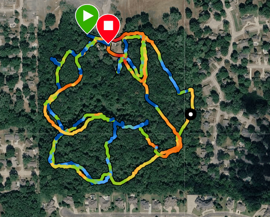
So this was my route. I’ve got a way of looping out and back where I can get almost three miles without too much duplication.
If you want to learn more about Leave No Trace, hit this LNT Link. Lots of good information there.
I am linking with Through My Lens. Go check it out, lots of great bloggers post there.


